Category Archives: News - Page 2

2011 CQ WPX Contest

I didn’t operate in this contest, but I took a video with my iPhone for about 20 minutes or so. I uploaded the video in three parts to YouTube, from my iPhone, so excuse the jumps at the end / start of each video. I know they’re not timed correctly, it was a visual approximation from the small screen of the phone. What you hear is a station calling “CQ,” which can be thought of as “Seek You,” and is a way of calling for any station listening to respond. Usually you can’t hear both ends of the conversation, but sometimes you get lucky and you can. The stations exchange a serial number (the running total number of stations worked) and signal report (usually five by nine, signifying five, or best, readability, and nine, or best, strength). See if you can follow along.

For more information on the CQ WPX Contest, visit their Website, http://www.cqwpx.com/.

W4NYK Blue Ridge 2-meter Net

Here is a short snippet of a net – basically, a session where one station acts to control a repeater and keeps a list of other stations who are standing by or passing traffic and “checked in” to the net, usually for the purpose of traffic handling. This is a 2-meter net that passes formal traffic and has an informal rag chew at the end.

The portion you heard was just for two of the alphabetical groupings they allow stations to check in with. You go by the first letter of the suffix of your callsign. Mine is Juliett, for example. As you can imagine, this net is very large, and it takes a long time to take all of the check ins! Sometimes up to around forty minutes!

9A50Z Pileup & My Current Portable QRA

Here’s a video (poorly shot by my iPhone 4) of me working 9A50Z, in Croatia. There was a pileup and it was tough for me to be heard, but I persisted and successfully tested my newest addition to my “antenna farm,” my 20-meter dipole. Also take note of my 1-wire Wx Station and my 10-meter, 75-meter, and 2-meter antennas. Enjoy my silly fun! (The video is about 9 minutes long, so only watch if you’re interested in it!)

The video was done amidst multitasking, so excuse my lack in train of thought. You see me work through a pileup (at 3:50) and then log him in my logbook. The contact was made on the first antenna shown (at 7:28), a home made 20-meter 1/2 wavelength horizontal dipole.

Massive Earthquake Hits Japan, Tsunami Warnings Issued

From the ARRL’s Website:

03/11/2011

An 8.9 earthquake struck Japan at 2:46 JST (0546 UTC) on Friday, March 11. According to the US Geological Survey (USGS), this is largest earthquake in 140 years to hit the island nation. The earthquake occurred in the western Pacific Ocean, 81 miles east of Sendai, Honshu, Japan. Its epicenter was 232 miles from Tokyo. News reports by the Tokyo Broadcasting System indicate that at least 200 people have died and another 88,000 are missing in six different prefectures. The quake triggered tsunami waves as high as 33 feet off the coast of Japan.

At this time, there are no reports of Amateur Radio involvement in the disaster response. Even so, IARU Region 1 Emergency Communications Coordinator Greg Mossop, G0DUB, has asked that extra care be taken so as to not interfere with any emergency traffic. The IARU Region III Emergency Center of Activity frequencies are 3.600, 7.110, 14.300, 18.160 and 21.360 MHz. Other suggested emergency frequencies being reported by Amateur Radio operators from Japan include 7.130, 14.230 and 21.230 MHz.

Icko Suzuki, JA1BPA, of Tokyo, told the ARRL that telephone lines and the Internet are “okay for the JA1 (Tokyo) area, but the Miyagi, Fukushima and Iwate prefectures (JA7 area) are hard hit and I cannot reach my brother who lives there.” Suzuki said that in Japan, emergency communications activities and support normally occur on 40 meters and on VHF, “so normal DX bands should not be affected.”

In Hawaii, Ron Hashiro, AH6RH, told the ARRL that his state is preparing for a tsunami: “The water level at Kahului Harbor — the main harbor on the Island of Maui — dropped 5 feet at 3:54 this morning HST (1354 UTC).” A quake measuring 4.5 was felt in Hawaii, 150 minutes following the Japan tremor.

Less than an hour after the Sendai earthquake hit, the Pacific Tsunami Warning Center (PTWC) in Honolulu, Hawaii, issued a Tsunami Warning for the State of Hawaii, saying that “an earthquake of this size has the potential to generate a destructive tsunami that can strike coastlines near the epicenter within minutes and more distant coastlines within hours.”

The PTWC also issued a Tsunami Warning for Japan, Russia, the Marcus Islands, the Northern Marianas Islands, Guam, Wake Island and Taiwan. A Tsunami Watch was issued for Yap, the Philippines, the Marshall Islands, Belau, Midway Island, Pohnpei, Chuuk, Kosrae, Indonesia, Papua New Guinea, Nauru, Johnston Island, the Solomon Islands and Kiribati.

The West Coast and Alaska Tsunami Warning Center (WCATWC) in Palmer, Alaska, issued a Tsunami Warning for the coastal areas of California and Oregon from Point Concepcion, California to the Oregon-Washington border and for the coastal areas of Alaska from Amchitka Pass, Alaska (125 miles west of Adak) to Attu, Alaska. A Tsunami Advisory was issued for the coastal areas of California from the California-Mexico border to Point Concepcion, California and for the coastal areas of Washington, British Columbia and Alaska from the Oregon-Washington border to Amchitka Pass, Alaska.

A tsunami is a series of long ocean waves. Each individual wave crest can last 5-15 minutes or more, and extensively flood coastal areas. The danger can continue for many hours after the initial wave as subsequent waves arrive. Tsunami wave heights cannot be predicted and the first wave may not be the largest. Tsunami waves efficiently wrap around islands. All shores are at risk, no matter which direction they face. The trough of a tsunami wave may temporarily expose the seafloor, but the area will quickly flood again. Extremely strong and unusual near-shore currents can accompany a tsunami. Debris picked up and carried by a tsunami amplifies its destructive power. Simultaneous high tides or high surf can significantly increase the tsunami hazard.

According to the BBC, coastal areas in the Philippines, and other parts of the Pacific were evacuated ahead of the tsunami’s expected arrival. The first waves, currently about 4 feet high, have started reaching Hawaii. New Zealand downgraded its alert to a marine threat, meaning strong and unusual currents were expected.

Initially reported as 7.9 by the USGC, the magnitude of the Japan earthquake was quickly restated as 8.8 and then 8.9. According to the USGS, this earthquake is the fifth strongest quake in the world since 1900, the seventh largest in recorded history and the largest tremor to hit quake-prone Japan in 140 years. The largest quake ever recorded hit Chile in 1960, measuring 9.5.

As of now, the only entities conducting emergency nets are the Oregon ARES®/RACES on 3.964 MHz and SATERN on 14.265 MHz. As the ARRL hears of more emergency nets related to the earthquake and tsunamis, we will post this information and frequencies on the ARRL EmComm Twitter page and the ARRL website.

See more via the ARRL Article.

ARRL Int.’l DX Contest

Don’t forget about the March ARRL International DX Contest, coming up this weekend, March 5th, where amateurs work as many amateur stations in as many DXCC countries of the world as possible on the 160-, 80-, 40-, 20-, 15-, and 10-meter bands. This year, the entry categories have changed. They are as follows:

Single Operator Assisted, High Power

Single Operator Assisted, Low Power

Multioperator, Single Transmitter, High Power

Multioperator, Single Transmitter, Low Power

Low power constitutes 150 watts or less. There are lots of little details to look over before deciding which category you want to fit in to, including whether you want to work a single band or multiple bands of radio, where your callsign indicates you are from (I’m operating portable 4, and so during the contest, my callsign must reflect that), and whether you will have assistance or operate alone.

Further, there are awards available (as usual), and they are categorized as follows:

1. Top W/VE scorer in each entry category; Single Operator, All-Band QRP; Single Operator, All Band Low Power; Single Operator, All-Band High Power; Single Operator, Single Band (160-10 Meters); Single Operator Unlimited; Multioperator, Single Transmitter; Multioperator, Two Transmitter; Multioperator, Multi Transmitter.

2. Top scorer in the Single Operator, All Band category worldwide and on each continent. In addition, worldwide leaders in the Single Operator, All-Band QRP; Single Operator, All Band Low Power; Single Operator, All-Band High Power; Single Operator, Single Band (160-10 Meters); Single Operator Unlimited; Multioperator, Single Transmitter; Multioperator, Two Transmitter; Multioperator, Multi Transmitter categories will receive plaques.

3. Additional special plaques will be awarded as sponsored.

Please see the ARRL Website for more detailed information, including a link to the official Contest Rules.

Even if you don’t have a HF transceiver, get in touch with someone who does and see if they wouldn’t mind if you observed or helped out. You don’t have to be licensed to help, either, so long as the station licensee is allowing you to.

73 & good luck!

1-wire Wx Station Project

Added a new page to the Projects Page. It’s about my portable 1-wire Weather Station. Check that out!

Severe Wx

Some pretty good severe Wx late this afternoon in Eastern TN, AL, northern GA, SC, and Western NC; still going on at this time. Check my Weather Page to see what’s happening. On the full North America radar loop map, you can click where you want to view closer detail, and it links to the closest radar site. From there, you can view Storm Relative Motion to get a good idea of any rotation or vortices, and you can check the Composite loop to see the stronger areas. Further, you can click to zoom in and you can change the options for viewing, such as whether you want to see the NWS warnings illustrated or not (they can get in the way of seeing details sometimes). Check it out.

Boy Scouts Chat

Did some chatting this afternoon with a Boy Scout troop over in Valdese, NC. They had an amateur call and then ask to do third party QSO, so I jumped in and did some chatting. What a great idea! W4JNH was the station who was allowing the third party communications for the troop. It sure can be a lot of fun to use radio, especially when you have a friend to use it with! I would imagine that in Boy Scouts, radio could be used all of the time, during their normal activities and events. Hopefully some of those guys were inspired to study and get their license! Good luck!

73,
K8JSM

APRS

Finally, I’ve gotten my APRS stations coordinated. I have a weather station transmitting via TCP/IP APRS, my iPhone portable station transmitting via TCP/IP APRS, and my mobile station transmitting via RF (using a TinyTrak4 by Byonics).

APRS works by sending a digital packet of information, via RF, to a receiving station (anyone can have a receiving station at their house with a receiver, computer, and Internet service), and then that station (referred to as an iGate) sends the information to the APRS servers via the Internet. The default 2-meter frequency used is 144.3900MHz, and so as you’re out driving (for example), you set your transceiver to 144.390, turn on your APRS TNC (in my case, a TinyTrak4), and it does the rest.

There are also “digipeaters” that listen for your packets and repeat them again, so they may be passed to an iGate, to be uploaded to the Internet APRS servers. I have my TinyTrak4 set up as a digipeater to repeat any path requests with “TEMP” or “SAR” in them. That means if my station hears another station with “TEMP” or “SAR” programmed in, it will repeat it for them. I do this because “TEMP” is used for temporary situations, such as Field Day or perhaps emergency or other situations, and “SAR” is used for search and rescue operations. If I participate in such events, I’m already set up to be of assistance by helping to get their packets out to an iGate, which can upload them to the Internet APRS servers.

There’s lots of reading out there on APRS; just go to Google and type in APRS Amateur Radio!


3-element Tape Measure Yagi

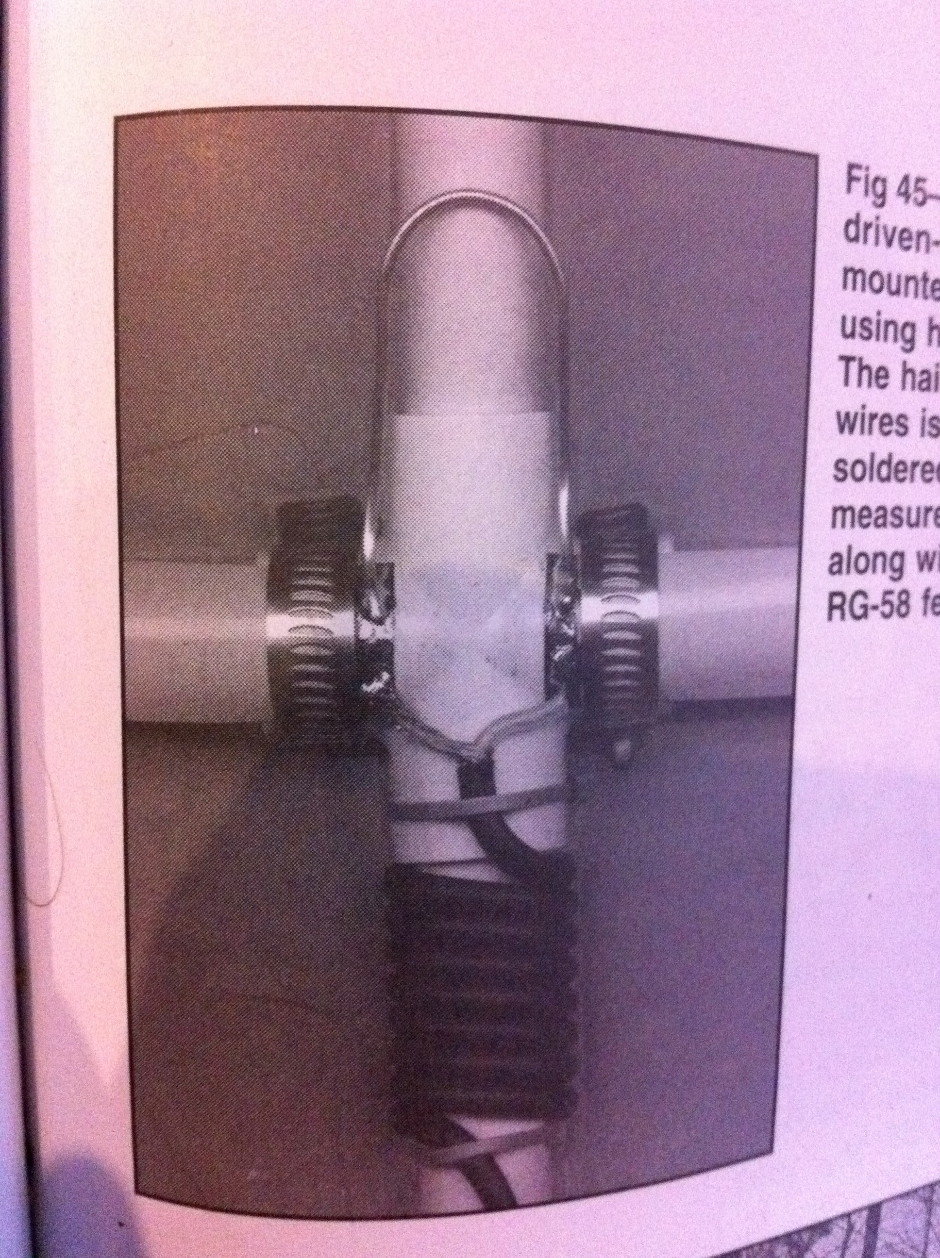
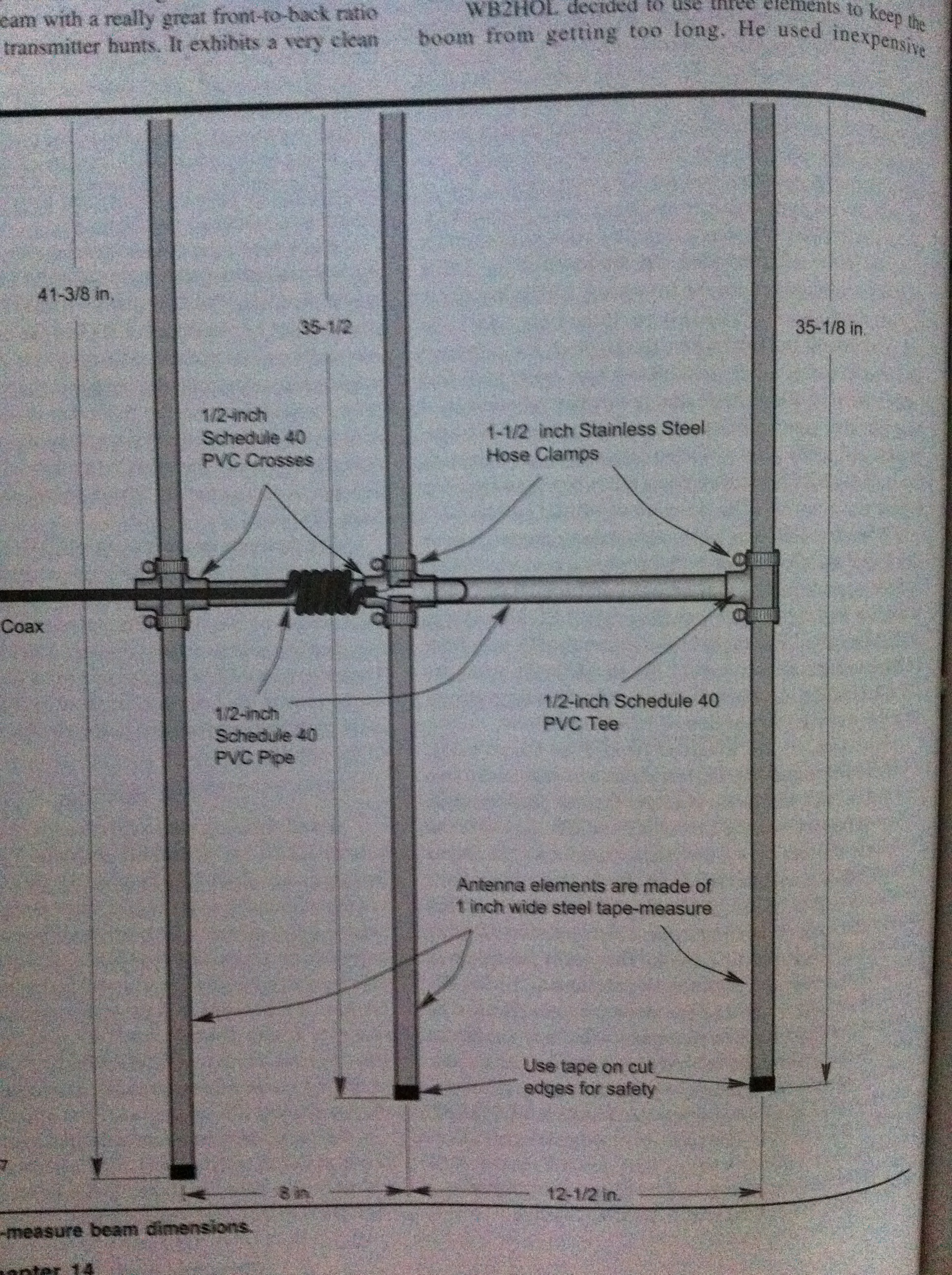
I’ve been wanting to build an antenna for radio direction finding (RDF) for a long time. I finally got the motivation to build one, so here are a couple pictures of the design from the ARRL Antenna Book. For pictures and more explanation from my build, check out the Projects Page.

Here is the design schematic.

Here is the matching section where the coax connects to the driven element.

It was a lot of fun to build and very easy to do. I recommend it for anyone interested in RDF or who needs a portable yagi for anything (including satellite work)!

To view more about the project, check out the specific Project page, called Tape Measure Yagi.