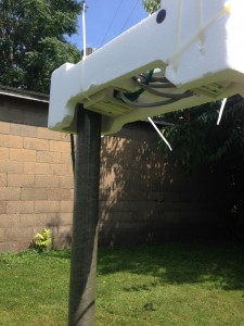
Threw my barometer, hygrometer, and thermometer outside of the window tonight. It’s super temporary, but it’s one baby step closer to getting things running. Currently located within a couple of feet of my house, temperature, humidity, and pressure are available at the right hand side of my page, on the weather page of this site, and at WunderGround and on APRS.
Category Archives: SKYWARN
Storms at Sunset
1-wire Wx Station Testing

Set out the 1-wire wx station to calibrate the sensors before mounting them in any semi-permanent way. My anemometer and windvane are placed between my and my neighbor’s house. It is a less than ideal position, but the length of ethernet cable is limited with this particular setup. So far, I have done one calibration on the three (of four) thermometers in my station, two contained in the Temperature/Humidity/Solar sensor and one contained in the Barometer. I recently repositioned those three thermometers to my back yard, from my driveway (which gave far too high temperature readings). I also created a makeshift radiation shield made from styrofoam and zipties.
I also updated the Website in a few places to show my weather data and webcam. You can see my weather data on the right side of the Home page of my Website and on the Weather page. The data is also transmitting to APRS-IS (Automatic Packet Reporting System) via Internet (this is considered “APRSWXNET“), which is then fed to the CWOP (Citizens Weather Observation Program), which is used by the NWS (National Weather Service) via the MADIS Program for forecasting and other purposes.
Slight Updates
Made a few modest updates relating to my personal (1-wire) weather station (mainly the Website). Plan to tower-mount it as soon as possible. Data being sent to APRS-IS and WunderGround. Data visible in the right hand column and on the Weather page. Also added APRS tracking to the right hand column that shows my position as I am using APRS in my vehicle (storm chasing or otherwise).
Sean
Severe Wx
Lately, I’ve been getting back in to SKYWARN severe weather spotting around Coshocton County, Ohio. It’s been a good bit of fun getting my portable wx station set up, but the really fun part is using it! (To see my portable wx station, click here.)
I still need to devise a way to latch this sucker down in very high winds. I’m experimenting with bungee cords and the roof of my car, but in the last storm, I didn’t have enough bungees to properly secure it, so I had to disengage it and just go without any data. Unfortunately, in my county, AT&T does not offer any coverage whatsoever, and I have no cell data available to me, so I can’t even view a radar image. It SUCKS, but I’m working on getting my own large area WiFi signal out, so I can access the Internet that way on my iPhone or netbook laptop.
I’ll post some pictures and updates about my trials and tribulations with the wx station as they become available (meaning, if I’m not being blown around in 40MPH winds, losing my hat, and trying to keep my station from falling over)!
1-wire Wx Station Project
Added a new page to the Projects Page. It’s about my portable 1-wire Weather Station. Check that out!
Severe Wx
Some pretty good severe Wx late this afternoon in Eastern TN, AL, northern GA, SC, and Western NC; still going on at this time. Check my Weather Page to see what’s happening. On the full North America radar loop map, you can click where you want to view closer detail, and it links to the closest radar site. From there, you can view Storm Relative Motion to get a good idea of any rotation or vortices, and you can check the Composite loop to see the stronger areas. Further, you can click to zoom in and you can change the options for viewing, such as whether you want to see the NWS warnings illustrated or not (they can get in the way of seeing details sometimes). Check it out.
APRS
Finally, I’ve gotten my APRS stations coordinated. I have a weather station transmitting via TCP/IP APRS, my iPhone portable station transmitting via TCP/IP APRS, and my mobile station transmitting via RF (using a TinyTrak4 by Byonics).
APRS works by sending a digital packet of information, via RF, to a receiving station (anyone can have a receiving station at their house with a receiver, computer, and Internet service), and then that station (referred to as an iGate) sends the information to the APRS servers via the Internet. The default 2-meter frequency used is 144.3900MHz, and so as you’re out driving (for example), you set your transceiver to 144.390, turn on your APRS TNC (in my case, a TinyTrak4), and it does the rest.
There are also “digipeaters” that listen for your packets and repeat them again, so they may be passed to an iGate, to be uploaded to the Internet APRS servers. I have my TinyTrak4 set up as a digipeater to repeat any path requests with “TEMP” or “SAR” in them. That means if my station hears another station with “TEMP” or “SAR” programmed in, it will repeat it for them. I do this because “TEMP” is used for temporary situations, such as Field Day or perhaps emergency or other situations, and “SAR” is used for search and rescue operations. If I participate in such events, I’m already set up to be of assistance by helping to get their packets out to an iGate, which can upload them to the Internet APRS servers.
There’s lots of reading out there on APRS; just go to Google and type in APRS Amateur Radio!


